
The regional river trail serves as the backbone of the trail system. Together with connecting trails, residents can access parks, entertainment, shopping, educational institutions and employment centers. Download Trail/Paseo Maps.
Trail Closure Information
Remember that trails are subject to periodic closure during severe rain events. While any trail is subject to closure during inclement weather, trail under crossings along the Santa Clara River and its tributaries are susceptible to flooding and may be closed without notice. City staff will monitor the trail system and closed sections will be reopened as soon as it is safe to do so.
Learn More About Our Trails!
 Iron Horse Trailhead (map)
Enter off the north side of Magic Mountain Parkway near Tourney Road Parking for cars and horse trailers, equestrian staging area, shade structure, information kiosk and drinking fountain on site.
Promenade Trailhead (map)
Enter off the west side McBean Parkway. Shopping center parking lot offers designated parking spaces for trail users.
Auto Center Trailhead (map)
Enter off the north side of Valencia Boulevard, at Auto Center Court Off street parking for vehicles and horse trailers. Benches, drinking fountain, and information kiosk on site.
South Fork Trailhead (map)
Enter off the south side of Magic Mountain Parkway, between Valencia Boulevard and Rail Road Avenue, on the South Fork River west bank. Off street parking for vehicles and horse trailers. Picnic tables and drinking fountain on site.
Camp Plenty Road Trailhead (map)
Enter off the south side of Soledad Canyon Road, at the Camp Plenty Road Off street parking available. Drinking fountain on site.
Lost Canyon Road Trailhead (map)
Enter off the south side of Soledad Canyon Road, at Lost Canyon Road, continue south under freeway underpass to trail entrance. Some street parking available. Benches, drinking fountain, water spigot, and hitching post on site.
For your convenience, bike lockers are available at the Via Princessa, Santa Clarita, and Jan Heidt Metrolink Stations and the Mcbean Transfer Station located at intersection of McBean Parkway and Valencia Boulevard. Call (661) 295-6300 to reserve a locker or for more information on bicycles and Metrolink.
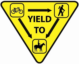 When using bike paths and multi-use trails, please follow these guidelines:
- Class I Trails open from sunrise to 10:00 p.m.
- Use trash receptacles provided.
- Motorized vehicles are prohibited.
- Observe posted trail use guidelines.
- Dogs must be leashed at all times.
- Dog owners must clean up after their dogs.
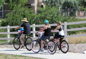
 Class I – Bike Path
Provides a completely separated right of way for the exclusive use of bicycles and pedestrians with cross-flow traffic minimized. The trails are marked and landscaped. Fencing encourages use of designated access points.
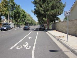
Class II – Bike Lane
Provides a striped lane for one-way bike travel on a street or highway. Bike lanes are marked with signs and pavement striping.
Class III – Bike Route
Provides for shared use with pedestrian or motor vehicle traffic. Bike routes are marked with signs.
Multi-Use Trail
Located primarily in rural areas, these trails are unpaved and are available for hiking, equestrian, and mountain bike use.
- Wear an approved bicycle helmet every time you ride. If you’re under age 18, it’s the law.
- Be Visible! Wear brightly-colored, reflective clothing, especially when using trails after dark. A white headlamp and rear-facing red light are highly recommended.
- When using trails after dark, wear reflective clothing, and use a light and reflectors.
- Keep your bicycle in good condition. Check brakes, tires, and handle bars every time you ride.
- Ride defensively, be alert, and watch for traffic and other trail users.
- Make sure your bicycle is not too big or small. You should be able to straddle your bicycle comfortably, with both feet touching flat on the ground.
- Ride single-file and only one person on a bicycle.
- Ride on the right side of the trail, follow lane markings, and use hand signals for turning, slowing, or stopping.
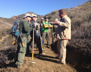 If you would like to volunteer in the upkeep of the trails system, contact the City’s Volunteer Engagement Program at (661) 250-3708 or visit SantaClaritaVolunteers.com.

Hiking in Santa Clarita
Visit HikeSantaClarita.com for more information on trails in the City Open Space areas.The City’s Open Space website is your one stop shop for all things hiking in Santa Clarita.

Biking in Santa Clarita
Visit BikeSantaClarita.com, the City’s official resource for cyclists! Discover suggested bike routes, upcoming bike events, bike clubs, bike maps and more!
To Report a Problem
Trail Maintenance: (661) 290-2224
Graffiti Hotline: (661) 252-5326
Sheriff: (661) 255-1121
Fire/Paramedics (Non Emergency): (661) 259-2111
City Hall: (661) 259-2489